
Aso Guest house
Cotton Club Cottage
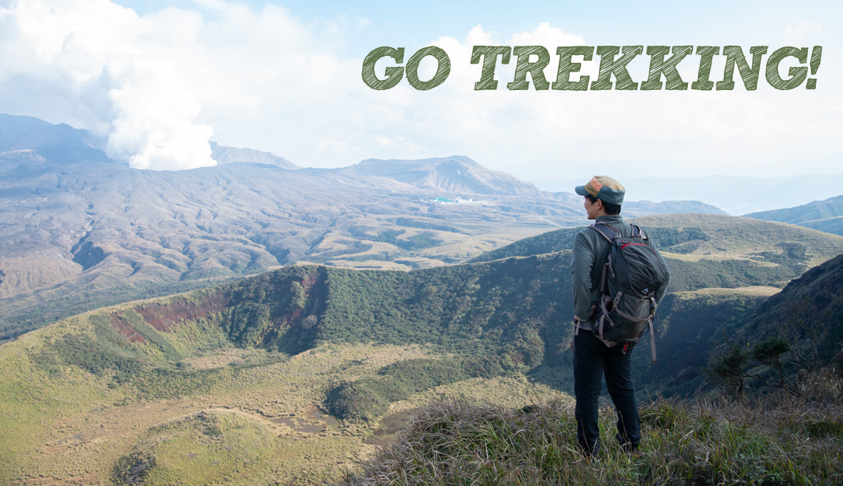
阿蘇に来たら、山登りを楽しもう!
Enjoy trekking when you come to Aso!
高いところから見ると、阿蘇の特徴的な地形はよりはっきりと見ることができます。山頂に着いた時、世界最大級のカルデラの雄大な景色が目に飛び込んでくると共に、そこに暮らす人々の息遣いを感じることでしょう。山登りの途中にも、鳥のさえずりやかわいい花など阿蘇ならではの自然に出会えます。
登山口から30分で頂上までいけるような初心者でも安心の登りやすいルートから、ロープを使って登るようなハードなルートまで、ゲストハウス周辺のオススメ3ルートをご紹介します。
From the top, you can see Aso's characteristic terrain more clearly. When you reach the top of the mountain, you will feel the magnificent scenery of the world's largest caldera, and you will feel the breath of the people living there.During the mountain climbing, you can encounter the unique nature of Aso, such as the song of birds and cute flowers.
Here are 3 recommended routes around the guesthouse, from easy-to-climb route that are easy to climb even for beginners who can reach the summit in 30 minutes from the starting point to hard route that can be climbed using ropes.
for bigginer
清栄山 Mt.Seiei
Mt.Seiei
低い山だし、景色もイマイチだろう...とあなどってはいけません。頂上では阿蘇ならではの雄大な景色が見られます!
秋、山頂ではススキの原っぱが黄金に輝きます。ファミリーにもおすすめの山。
It’s a low mountain, so the scenery is not good? No! at the top, you can see the magnificent scenery unique to Aso!
In autumn, the silver grass field shines golden at the summit. We also recommend for families.
山データ
- 標高:1006m
- 登山口標高:870m
- 標高差:136m
- ・ルート概要(距離,時間)
- 登山口 → 頂上 600m,25分
- 頂上 → 登山口 600m,20分
Mountain data
- Altitude: 1006m
- Trailhead elevation: 870m
- Altitude difference: 136m
- ・Route overview (distance, time)
- Trailhead → Top 600m, 25 min
- Top → Trailhead 600m, 20 min
登山口データ
- 黒岩峠に登山口あり。駐車スペースは6台程度。
- ゲストハウスから駐車場まで車で15分
Trailhead data
- There is a trailhead at Kuroiwa Pass. There are about 6 car spaces.
- 15 minutes by car from the guesthouse to the parking lot.
必要な装備
- スニーカーで登山可能。秋・冬は防寒着。
Necessary equipment
- You can climb with sneakers. Warm clothes in autumn - winter
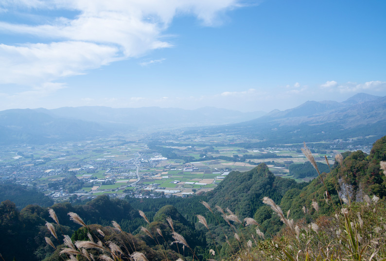
頂上からは南阿蘇と阿蘇五岳を見ることができる
From the top, you can see south caldera and Mt.Aso
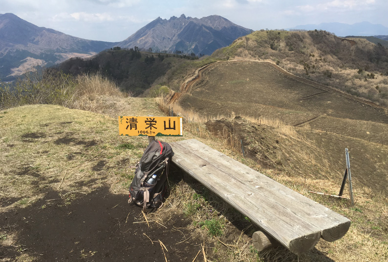
頂上にはベンチがある。のんびりお弁当を食べるのも良いかも
There is a bench at the top. It may be good to eat a lunch
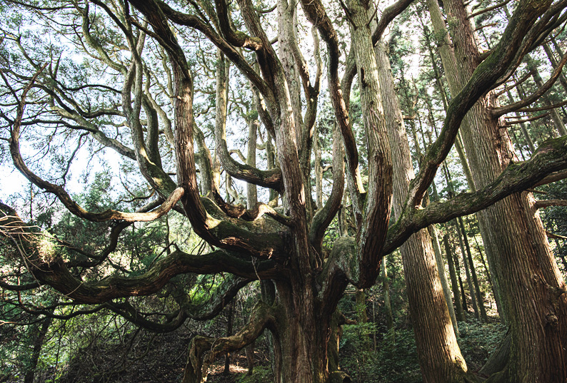
時間があれば、駐車場までの道中にある「高森殿の杉」へ行くのも面白い
If you have time, it's interesting to go to Takamori-donno Cedar on the way to the parking lot
for intermediate
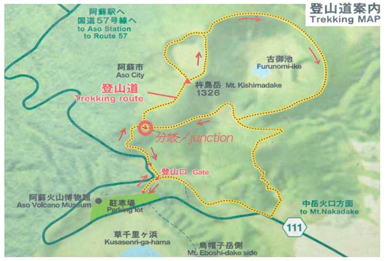
杵島岳 Mt.Kishimadake
Mt.Kishimadake
ダイナミックな景色が次々と現れるエキサイティングなルート。杵島岳山頂まではアスファルト舗装されていて登りやすい。
山頂で火山の噴煙を見た後は、昔火口だった古御池火口跡(ふるのみいけかこうあと)の縁を歩いてみよう!きっと貴重な体験になるはず。
An exciting route where dynamic scenery appears one after another. It is easy to climb up to Mt.Kishimadake bacause of covered with asphalt.
After seeing the volcanic plume at the top of the mountain, let's walk along the edge of Furunomiike crater! It must be a valuable experience for you.
山データ
- 標高:1326m
- 登山口標高:1140m
- 標高差:186m
- ・ルート概要(距離,時間)
- 登山口 → 分岐 700m,20分
- 分岐(杵島岳へ) → 頂上 500m,35分
- 頂上(古御池火口跡を回る) → 分岐 2.4km,70分
- 分岐(草千里ヶ浜へ) → 登山口 700m,15分
Mountain data
- Altitude: 1326m
- Trailhead elevation: 1140m
- Altitude difference: 186m
- ・ Route overview (distance, time)
- Trailhead → Branch 700m, 20 minutes
- Branch (to Mt.Kishimadake) → Top 500m, 35 minutes
- Top (turns around Furunomiike crater) → Branch 2.4km, 70 minutes
- Branch (to Kusasenrigahama) → Trailhead 700m, 15 minutes
登山口データ
- 阿蘇火山博物館前の草千里駐車場に登山口あり。駐車料金500円。
- ゲストハウスから駐車場まで車で35分
Trailhead data
- There is a Trailhead in the Kusasenri parking lot in front of the Aso Volcano Museum. Parking fee is 500 yen.
- 35 minutes by car from the guesthouse to the parking lot.
必要な装備
- 山頂まではスニーカーで登山可能。
- 古御池火口跡に行く場合はトレッキングシューズ推奨。
- 秋・冬は防寒着。
Necessary equipment
- You can climb with sneakers to the summit.
- Need Trekking shoes and long sleeve when going to the Furunomiike crater.
- Warm clothes in autumn - winter
全行程2時間半程のアップダウンのあるルート
Route with up and down of about 2.5 hours on the entire journey
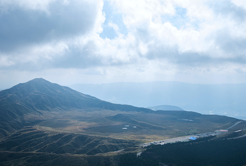
杵島岳を登ると徐々に見えてくる、草千里全景とその奥が烏帽子岳
As you climb up Kishimadake, you can gradually see the whole view of Kusasenri crater and the back is Mt.Eboshidake
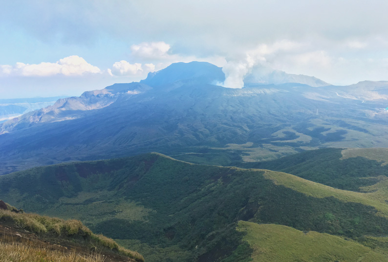
山頂の景色。火口から立ちのぼる噴煙と眼下の古御池火口跡
View of the mountaintop. Volcanic plume rising and the trace of the Furunomiike crater below
for advance
根子岳東峰 Mt.Nekodake EastPeak
阿蘇に訪れたら一度は登りたい山。阿蘇のカルデラを北から南まで一望できる最高のパノラマが待っています。
登山道はほぼ急坂で、ロープを伝いながらのルート。アトラクション的な登山の楽しさも味わえる。
山データ
- 標高:1408m
- 登山口標高:1065m
- 標高差:343m
- ・ルート概要(距離,時間)
- 登山口 → 分岐 600m,70分
- 分岐 → 頂上 100m,7分
- 頂上 → 分岐 100m,7分
- 分岐 → 登山口 600m,35分
登山口データ
- 大戸口から前原牧場に入り、奥まで進むと駐車場と登山口あり。
- ゲストハウスから駐車場まで車で20分
必要な装備
- トレッキングシューズ
- グローブ
- 防寒着
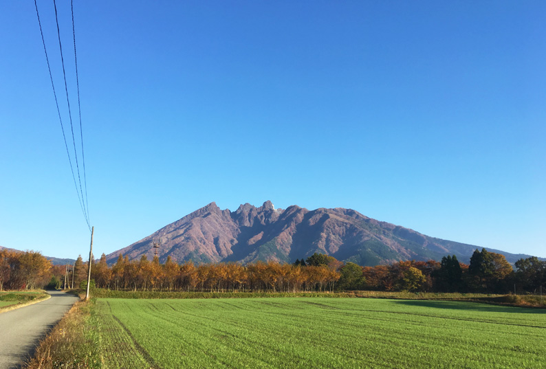
ゲストハウスからも根子岳が見える。ギザキザの形がユニーク
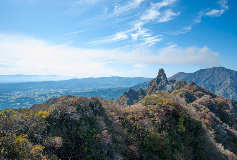
山頂に登ると360°のパノラマビュー。カルデラの縁が北から南まで見渡せる
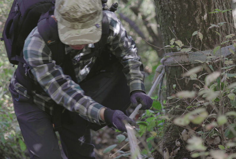
登りも降りもロープを伝っていく。グローブがあると良い